Today was given over to the drive from Marree to Wilpena Pound in the Ikara-Flinders Ranges National Park. An early breakfast and top up of diesel and I was back again on sealed highway.
FARINA
50 km south of Marree lies the deserted town of Farina. What makes it an interesting stop is that a group of volunteers are slowly restoring the ruins to create a museum township. In the 1890s the town had a population of 600 — a school, bakery, 2 pubs, police station, Anglican and Catholic Churches, rail station and associated loading facilities. The old town has been mapped and signposted by the volunteers, and several buildings are resurrrecting from the rubble. Did I mention the all-important brothel?
LYNDHURST
Another dying town along the old Ghan rail track. Not much more than the pub and a caravan park there now. Just out of town lives a real character who goes by the name of Talc Alf. He is staunch republican and has been lobbying to have the Aboriginal flag replace the Union Jack in the corner of our national flag. Alf lives hermit style life, and the talked me blind for 40 minutes with his quirky theories of name meanings and history. He is clearly a well read, educated and widely travelled 75 year old who now passes his time carving fugues in talc stone. The hills nearby have been a secret quarry for thousands of years for aborigines after ochre for body painting. A trade in red and white and yellow ochre (or talc) from here has existed right across the country. Alf gets slabs of this talc stone and carves it using simple scraping tools. He has an interesting gallery on show. He is easily the most interesting person I have met on my travels here.
BELTANA
Several km off the highway Alain’s a gravel road one is supposed to come to the “historic town” of Beltana. Problem is that when one arrives a sign greets you telling you that Beltana is “closed” .. it has gone for historic to history ! I suspect a few other tiny outposts are heading the same way. Near the former town is the Afghan Well. A bore supplies drinking water that flows into a long trough where camels used to drink. A large holding yard there was used by the cameleers while they organised the loads they were to transport onwards. The well and trough are still functioning, and today a small flock of sheep was using it to quench their thirst.
PARACHILNA
Next historic stop was Parachilna with its “historic pub” the Prairie Hotel. Had lunch there. They offer all sorts of bush tucker on the menu, as well as pies from assorted animal meats. I settled safely for a beef pie! The area is famous for the discover there of the Ediacaran fossils. These are fossilised remnants of the very earliest living creatures on earth, leaflike in shape but probably jelly-fish like in structure. None were on display, but they have some metal sculptures there depicting the major finds.
Wilpena Pound was my next destination. I had intended travelling via Blinman and down the sealed Flinders Way to the resort. Somehow I took a wrong turn and ended up on a narrow winding track that led through two gorges, the Brachina and the Bunyeroo. The scenery was spectacular, especially when the track wound through a narrow gap in the ranges, with brightly coloured sheer rock faces towering above me. Eventually I exited onto the Flinders Way and reached the Pound resort at 4pm.. a good hour later than I had planned.
The resort is run by local aboriginal companies, and 70% of staff are indigenous. All very courteous and helpful. My room is comfortable and well heated (overnight expected to go close to frost). I quickly discovered the whereabouts of the guest laundry, rounded up a supply of dollar coins from reception and got my clothing supply back to 100% clean.
Tomorrow I will attempt a walk to one of the lookouts that allow one to view the pound. Maybe take a drive back to Blinman that I missed today. And today’s photos are. here

Monday, July 22, 2019
Sunday, July 21, 2019
Day 9 — Fri 23/8/2019
WILPENA POUND
If you can imagine a large soup bowl, the sides of which are a circle of mountains surrounding a flat plain of lightly timbered land — that’s Wilpena Pound. Called a pound because it resembles an animal enclosure. In recent times it has been home to a cattle station and later a wheat farm. Now it is National Park. The resort lies just outside the circle of mountains that make up the central Flinders Ranges. It has catered accommodation and a caravan park. There is an IGA store, an information centre, and the main building houses restaurant and bar.
I treated my self to their hearty breakfast at 8 am, and then took the shuttle bus to the trailhead. This saves 2km walk each way ( so an hour in time). The track in is along Siding Spring creek which even in this drought period has running water from natural springs. After a 1 km walk the old homestead comes in view. It has been restored and is quite a picture in its sandstone exterior. Several trackers lead away from here. I took the one to the Wangarra lookouts. Quite a steep climb over rough rock for 500 metres. The lower lookout is a platform that extends off the cliff face. It gives a 270 degrees view of the pound — really quite spectacular in the mid-morning sunlight. My knees and lungs decided I should call it quits there. The remaining climb to get a full 360 degrees view looked almost vertical. I returned slowly to the trailhead in time to get the 11.15 am shuttle bus back to the resort.
BLINMAN
After a light lunch I drove the 60 km along the sealed Fliders Ranges Way to the village of Blinman, South Australia’s highest town at 626 metres. In the late 1800s it was a flourishing copper mining town. Today just a pub, post office, memorial hall and a cou8ple of old miners cottages remain. The old copper mine has been turned into a tourist attraction. I took a one hour guided tour underground.
Copper was discovered here in 1859 by a shepherd. He and 3 mates took a year to save the ten pounds it cost to take out mining lease. Since they had no capital to mine the area themselves they sold the lease to a British mining company for 70,000 pounds. Miners were imported from Cornwall, and they lived in terrible conditions in tents, working 12 hour shifts. Family groups mostly. Boys 10-14 worked above ground, and on their 14th birthday lads could join their dads and uncles underground. The mine had lots of ups and downs and closed in 1907. Local Progress Association took over from State mining in the 1970s to develop it as a tourist feature that might rescue the town from oblivion. The tour was interesting, taking us through the top three levels of the mine that goes down to 146 metres in the main shaft.
On the drive back to Wilpena I called in to a couple of lookouts that give different views of the Flinders Ranges. Actually the Flinders Ranges are a series of different mountain chains that stretch 400 km across central and northern South Australia. The Wilpena Pound is central and the best developed for easy access from Adelaide. On the short drive up to Stokes Hill lookout I passed at least 100 wallabies grazing in the cooler afternoon sun. Never seen so many in one place before, and they seemed relatively tame. The rest of the drive back was marked by even more wallabies near the road edge.
Reached 19C today, so pleasant and sunny. Already tonight it is a chilly 8C, so the heater is doing a good job in my room. Today’s photos are mostly of mountains. I am afraid that the camera doesn’t do justice to the splendour of the scenery here. I think a movie camera that allowed for panning and zooming would much better capture the stunning views I have been enjoying. But in any case, what I have taken is on show here
Saturday, July 20, 2019
Day 10 — Sat 24/8/2019
The final leg of my journey today — 440 km from Wilpena to Adelaide. I decided to take a more easterly route back so that I would have different scenery from my northbound leg. The day started out sunny and pleasantly warm at 19C, but on the way through the Clare Valley I encountered my first cloud and rain (just showers) of the entire trip. Not heavy enough to wash the car though!
I took my time, stopping for the occasional photo, coffee or leg stretch. Left at 9 a.m and arrived at motel at 4 p.m. Passed through a lot of small towns along the way. What characterised most was that they seemed to be struggling for existence. A lot of historic old stone buildings have been restored and renovated for modern day use. They all have their own bakery and cafe, which is a wonderful change from service stations with McDonalds attached.
Passed through Hawker, Quorn, Wilmington, Melrose,Murray Town, Wirrabara, Laura, Gladstone, Bungaree, Clare, Sevenhill, Auburn, Tralee, Roseworthy, Gawler, Elizabeth and Salisbury. The stupid nav system then took me through the main streets of the cbd to reach the motel, a painfully slow process.
Quorn has a steam railway museum, and still runs an old steam train to Port Augusta on the old Ghan track for tourists. Called the Pichi Richi train. At Wirrabara the old wheat silos at the railway siding have been given the “silo art” treatment. Features a farmer and a local bird. Very colourful and really excellent paintwork. By the way, most of the rail crossings I passed over on this trip had a small sign erected next to them “Rail crossing not in use “. Indicative of how the times have changed for these country towns. I stopped in Clare at local bakery for lunch. After that the road was lined with vineyards and cellar doors, mostly small brands not familiar names. Did pay respects to the Jesuit winery at Sevenhill. Opposite it was a small cellar advertising “Good Catholic Girls” wines. Had to get a photo of that ! At Gawler passed by a very impressive looking racetrack.
By contrast with previous days travels, the countryside today was lush green instead of barren desert. Sheep grazing contentedly everywhere. Colourful yellow fields of canola interspersed the green of other crops. But the drive into ADELAIDE through the suburbs is just like any other city with its fast food outlets, used car lots, and light industry. Only the place names would let you know you are not in Brisbane or Sydney or Melbourne. Which makes me appreciate all the more the uniqueness of the outback country I have just had the pleasure of exploring.
That brings my travels to an end. A quiet night here at the hotel, out to the airport at 7.30 am in the morning to surrender the car and line up for the 9 am flight back home. I’ve thoroughly enjoyed the past 10 days, and especially the small town bakeries that give character to our outback. I hope you have enjoyed reading about them.
The last of the photos are here
Tuesday, September 11, 2018
The Kimberleys

The Kimberley region is a vast wilderness covering the north west corner of Australia. It is one of the oldest settled areas on the continent, with Aboriginal presence here for over 50000 years as migration pushed south from the Indonesian archipelago.
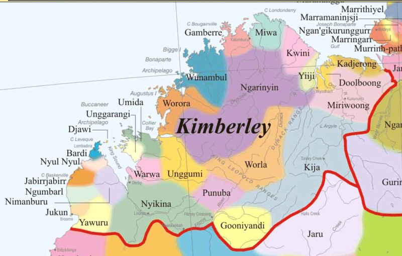
There is evidence of ancient trade with China, long before European settlement. The diversity of indigenous culture is highlighted by the fact that this corner of Australia was home to 27 distinct tribes / language groups. Today they make up roughly half of the 35000 people who call the Kimberley home. Some 25 native title claims are being pursued.
The economy of the area is diverse also. Pastoral (huge cattle stations), gold mining, fishing, agriculture (Ord River scheme), pearling and tourism all contribute.
Monday, September 10, 2018
Sunday, September 9, 2018
It's a long way...
Tonight I am in Broome, but it was along journey to get here. The 8.45 am flight from Brisbane, a crowded Boeing 737-800, took 5.5 hours to cross the continent to Perth. A couple of hours at the airport waiting for the connection to Broome. I managed to find a quiet spot where I could stretch
 out on the carpet and do some leg stretches in an attempt to keep my left thigh pain free. The Airbus A320 took 2.5 hours to cover the distance to the Kimberley coast, arriving at 5.45 pm local time. A shuttle bus finally delivered me to the Blue Seas Resort at Cable Beach at dusk.

The apartment here is spacious, comfortable and well appointed. I limped 200 metres down the road to the local eating spot, the ZeeBar. Had the tastiest, juiciest, tenderest Eye Fillet in memory! Before I hit the bed I just need to do a little planning as to how I will spend my time tomorrow. It promises to be a fine, warm day.
Saturday, September 8, 2018
Broome - 1 Sep 2018
A glorious day here to start Spring -- clear blue skies and 26C. My first task was to taxi in to the International terminal at the airport where Thrifty car rental have their depot. I took possession of a near-new Pajero Sports, the largest car I have ever driven, and a diesel to boot. It is a joy to drive once one gets used to its length and width .. And try to remember that the trafficators are on the right.

McDonalds was nearby so provided an easy breakfast. I drove around Chinatown to get a feel for the central town, then headed to the town's 2 museums for a history lesson. Both are well set out and a fund of information. The town museum concentrates on the history of Broome's pearling industry with lots of photos and memorabilia on show. At first it was the pearl-shell that was valued, used especially in Europe to make buttons and knife handles. Once cheap plastics took over the pearls themselves became the focus. The living and working conditions of the divers were pretty terrible, resulting in many deaths and crippling injuries.
The second museum is in the old convent of the St John of God Sisters, and it is a superb record of the nuns' work in Beagle Bay and Broome over many decades. They were predominantly concerned for care and education of aboriginal children, but also worked in hospitals and with other Christian church agencies. The photography and information banners at a this museum are as good as any I have ever seen. As is common, no photography allowed at either place!
The Catholic cathedral was next door to the SSJG property, so I paid a visit there. A couple of interesting aboriginal paintings, but no explanation of their meaning. The icon of the church's patron, Out Lady Queen of Peace, is an interesting mix of artistic styles.
Broome must be the roundabout capital of Australia. You hardly drive a few hundred metres without zigzagging through one. It certainly keeps the speed of traffic down. The streets allow next to no parking or stopping along the kerb. You have to look for parking bays that are set in the wide footpath area. Quite a problem if you need stop suddenly to consult a map or navaid.
After lunch and a nap I headed over the do a wander through the town's cemeteries. A good source of history. The Japanese cemetery is laid out neatly with crushed white granite. There are over 700 graves there, mostly of pearl divers killed on the job. There is a small Malay and Muslim plot too and a nicely gated Chinese cemetery. Unfortunately there is no historical information attached to it.

Late afternoon now, and I headed to Cable Beach -- so named because the undersea telegraphic cable from Java came ashore there. Parking was a search as hundreds of visitors crowded the area to watch the sun go down off Cable Beach. A perfect evening for it, with clear blue sea and a cloudless sky. I thought I'd see the famous camel ride at sunset -- but it was apparently along a different stretch of the beach. I did the see camels returning home past my resort a littler later riderless.
As is my wont, I headed in to the local RSL for dinner -- only to find that it was closed for a private function. So I found a nice seafood cafe nearby and settled for the local barramundi. Across the road is the world's longest operating "picture gardens" . An open air cinema in garden setting showing the very latest releases. From the number of cars parked nearby I think they had a reasonable patronage tonight.
Something that strikes me is the large area of scrub that splits the town up into several distinct sections. It was explained to me that they are tidal flats that fill up with extra high tides. By giving the tidal water a place to spread out, they save the residential areas from flooding. In summer they do have the disadvantage of breeding sandflies and bringing an occasional crocodile into the area.
Tomorrow I head off for Derby. Today's photos can be found Here
Friday, September 7, 2018
Derby - 2 Sep 2018
You are never too old to have a new experience! I did breakfast this morning at the Runway Cafe after I attended 7 am Mass at the Cathedral. Outdoor tables, each knitted out with a wooden box containing salt and pepper shakers, sugar, cutlery and napkins .. A common enough arrangement these days. But also in each box was a can of AEROGARD to deal with the flies!! That was a first for me.

I got on the road at 9 am, taking National Highway 1 towards Derby. The road was in good condition and presented no problems. Lots of traffic, mostly 4WDs but plenty of caravans and road trains as well. Quite a boring drive. The countryside is completely flat, not a hill in sight anywhere along the 230km journey. Covered in thick scrub as far as the eye can see, with a good sprinkling of termite mounds adding variety. Passed a few turn-offs into cattle stations, and in the middle of nowhere a very large abattoir. I stopped for a leg stretch and Weiss bar at the Willare Bridge roadhouse, an hour south of Derby.
Booked in to the Spinifex Hotel, sampled their lunch menu, and had a nap. The hotel is quite modern, with a large accommodation block next to the tavern. Outwardly it has somehting of the appearance of miners' quarters with lots of corrugated iron and steel pipe structure. But inside the apartments are really first class. Spacious, with a lounge area for TV watching, fully fitted out kitchen, laundry and bathroom. Good aircon. One could very comfortably spend a week or two here if ever had a need to be stuck in Derby that long.
The town claims to be the oldest in Western Australia, being gazetted in 1883. Population is 4500, so it is pretty much a typical small country town. A Woolworths and a big BP service station are the only big city businesses that I could see .. All the rest small and local. The main street is split by an avenue of Boab trees, making for an attractive aspect. But when I did a drive around the back blocks, the overall impression is of a very tired and somewhat neglected place.

On the way in to town I stopped at the Prison Boab tree which has been carefully preserved and provided with excellent information plaques. This was an overnight stopping place where groups of Aborigines chained together we're being marched to Derby to be pressed into service on the pearling fleet. At least the local historical society is upfront about the horrors of those days when the young men were rounded up from all over the Kimberley and walked in chain gangs for many of them to early death at sea. The local Pioneers Cemetery is home to their graves, but are all unmarked and unknown now. Near the Prison Boab Tree is a bore that was sunk in 1910 to provide water for cattle being driven to the port. A windmill still pumps water from the bore today -- but just as an historic memento.
Derby has the largest tidal range in Australia at 11 metres. I joined many others at the wharf to see the sun go down across King Sound. It was near high tide, so didn't get a feel for the huge difference between high and low tides. There is a very nice fish restaurant at the wharf with a beautiful outlook over the water, so I settled for their grilled barramundi and prawns with mash and veg for dinner. The breeze even got a little chill to it, a change from the 30+ daytime temperature.
The town is home to the Kimberley School of the Air -- drove past their setup near the high school, but of course Sunday meant everything was closed. The Flying Doctor is also based here at the airport a few km south of the town. There is a disused jail on the edge of town, seemingly occupied now by Aboriginal squatters. The hospital is much larger than I expected, but it has to service a very large area of the Kimberley and not just the townsfolk. The Catholic church was locked tight and has a sizeable and well appointed primary school attached. And that was about all Derby had to offer me on this sleepy Sunday.
Today's photographic offerings are here.
Thursday, September 6, 2018
To Fitzroy Crossing -- 3 Sep 2018
Today might be described as "a taste of ..." I will explain!

Started out after an early breakfast at the hotel, and soon had my first taste of the infamous Gibb River Road. To my surprise, the first 50km was top quality sealed surface. The next 30km was on a side track beside the main road which was being restructured and sealed, speed limit 40 kph much of the way. The remaining 40km to the Leopold Downs turnoff was OK gravel. I set the cruise control to the recommended 70 kph and found that the car handled the corrugations relatively smoothly in 4WD. Had to watch for sandy patches though, especially on corners, to avoid swerving.
The Leopold Downs road is all gravel and not as well maintained as the Gibb River Rd was -- but still able mostly to keep a steady 70 kph. 21 km along I reached the first stop of the day: Windjana Gorge. Here I came face to face with the Devonian Reef, a quite spectacular geologic feature that rises out of the flat surrounds of the Kimberley Savannah. 360 million years ago all this area of the Kimberley was submerged below a shallow sea. Over the centuries a barrier reef was formed that stretched from beyond today's Fitzroy Crossing to near Derby and out to sea. In time that land surface lifted and the sea drained away, leaving the reef rising between 100 and 300 metres from the old sea bed as a limestone range. It has a quite startling aspect to it. At Winjana Gorge the Lennard River has carved a path through the reef, creating a gorge with sheer cliff walls. The many layers of coral that formed the reef lie exposed in the cliff face. Apparently the area is a treasure trove for scientists who continue to uncover fossil remains of prehistoric sea life here.
I did the first 1km of the gorge walk to get a taste of its bird and animal life, as well as to admire the beauty of the towering limestone walls. The river at this time of year consists of a series of billabongs. In the first I counted 10 freshwater crocodiles lazing in the water, and a couple sunning themselves on the beach. I kept my distance on the high bank. Signs assure the visitor that the crocs are not aggressive unless you get between them and the water! I didn't attempt to check that out.

A little further along the road are the ruins of the Lillimooloora police station. In the 1890s the local Aboriginal people fought against the pastoralists taking over their land. This isolated police outpost was an effort to offer protection to the settlers. In 1894 a local Aboriginal working as a tracker changed sides and set prisoners free, murdered the police sergeant and stole all the weapons. He then led the police and pastoralist a merry dance for a couple of years before he was finally cornered and shot dead at Tunnel Creek. Hard to imagine a policman's life back then so far from the nearest town and with just a couple of horses and a tracker to help.
40km further down the road is the Tunnel Creek national park. Here the creek has worn away a 750 metre cave through the Devonian Reef that the adventurous can wade through. I went all prepared with torch and flip flops, but all I was to get was a taste of the tunnel. The entrance is reached by scrambling over a series of huge boulders which my legs had nowhere near enough strength to handle. So reluctantly I had to make a strategic withdrawal.
The remaining 30km of gravel to meet up with National Highway 1 was uneventful. Back on the 110 kph highway was a short 40km run into Fitzroy Crossing. The Fitzroy River is the largest in Western Australia, over 500km in length from its origin in the Durack Ranges to its mouth at Derby and King Sound. Until 1974 the national highway would frequently be blocked for weeks in the wet season by flooding on the low level crossing. A single lane high level bridge now eases that problem. The township is quite small, some 1500 people. Lots of Aboriginal industry apparent. Several of the nearby cattle stations are run by Aboriginal communities.
After checking in to the Fitzroy River Lodge (all the motel rooms are on stilts in case it rains too heavily!) I drove 20km out to Geikie Gorge National Park. The river has permanent flow here and an 80 seat sightseeing boat takes on for an hour's float up and down a very scenic stretch. The commentary by a local indigenous ranger lady was excellent, and she took the boat very close to the gorge walls to point out interesting features. A nice relaxing end to the day's travels. A rather expensive dinner in the Lodge's restaurant has me ready for bed!
Relevant photos can be viewed here.
Wednesday, September 5, 2018
To Mabel Downs -- 4 Sep 2018
Lots of driving today. Did a drive around Fitzroy Crossing township to see if I had missed anything worth exploring. Drove out to the original concrete causeway that had been the only path across the river for ages. Coudn't drive across it as the road down the cliffs is barricaded closed. Topped up diesel and hit the road, next stop Hall Creek. Along your way there was a nice rest stop set high on a cliff with all conveniences. Good place to stretch the legs.

Just before Halls Creek there is a major turn off south, prominently signposted ALICE SPRINGS. Not an expected destination from up here. But it is in fact the start of the 1000km Tanami track, one of Australia's famous cross desert 4WD adventure trails (think also the Birdsville Track). I kept driving!
Halls Creek presents as a very civic proud township. Bright signs everywhere, neatly kept streets, free wifi in the town centre, and a very comprehensive tourist information centre. This was a gold mining centre, and I think a small amount still goes on. In the Tourist Centre there was a display cabinet with small nuggets of the local product for sale, a couple at $10,000 and $13,000. I commented to the attendant that they were brave having such valuable merchandise on display in a simple glass cabinet. "There's a lock on the door" she replied, apparently quite unaware of how easy a smash and grab would be! The Shire Council collaborates with the local Lands Council to provide local employment in small arts industries etc.. The paintings I saw at the main gallery seemed very over-priced to me.

Another 150km along Highway 1 brought me to the Mabel Downs Caravan Park turnoff. I was all booked in and quickly shown to my Safari tent which is mounted on a timber platform on stilts. It was quite stuffy at first, having been all closed up in the heat of the day. A nice breeze came along just after dark and cooled things down nicely. The tent has a very comfortable double bed and an ensuite with shower, toilet and washbasin. No power. Lighting courtesy a couple of battery lanterns. Sat on the balcony after a pizza dinner and marvelled at the stars. I had forgotten what the Milky Way really looks like. The campground is very quiet, and I slept soundly. The wallabies around seem pretty tame, so I suspect they find food to suit their tastes here.
Today's photographic offering can be found here.
Today's photographic offering can be found here.